Wildfires in numbers
Why a small share of wildfires causes most of the destruction
A US study found a striking imbalance between fire numbers and losses. Three figures explain why rapid growth deserves attention.
In a study of more than 60,000 US fire events, fast-growing fires made up just 2.7% of the events analysed. Yet they accounted for 78% of recorded structures destroyed. A small share of fires carried a much larger share of the damage.
The findings, published in Science in 2024, cover the contiguous United States from 2001 to 2020. They give land managers and communities a reason to look beyond the number of fires when thinking about their consequences.
The imbalance in three numbers
The researchers counted a fire as fast-growing if it gained more than 1,620 hectares on at least one day. That is 16.2 square kilometres. This measures growth in burned area, rather than the speed of a flame front in kilometres per hour.
The study in three figures
A small share of fires, a large share of losses
Contiguous United States · 2001–2020 · fast fires’ share of each total

View chart data & downloads
Download data (CSV) · Download chart (PNG)
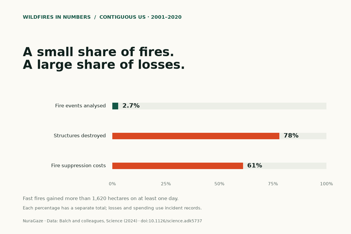
| Measure | Fast-fire share | Total used |
|---|---|---|
| Fire events analysed | 2.7% | 60,012 satellite-delineated events in the FIRED record |
| Structures destroyed | 78% | Structures recorded destroyed in the study's ICS-209-PLUS incident records |
| Fire suppression costs | 61% | Suppression expenditure recorded in the study's ICS-209-PLUS incident records |
Fast fires also accounted for 61% of recorded fire suppression costs: the money spent fighting fires. This is a different measure from the value of buildings lost, insurance claims or the wider costs of recovery.
What makes a fire grow quickly?
Fire behaviour depends on the material available to burn, the weather and the shape of the land. Dry vegetation ignites more readily because less heat is needed to remove its moisture. Wind supplies oxygen and pushes flames towards fresh vegetation, while slopes can bring unburned plants closer to the heat rising from below.
These factors work together. A windy day over dry grass presents different conditions from a damp, sheltered woodland. Even within one landscape, changes in wind, vegetation and terrain can alter how a fire develops. The US National Park Service explains these three influences as the fire behaviour triangle. Our guide to wildfire spread looks at them in more detail.
How does fire reach buildings?
Wind can carry burning fragments, called embers, ahead of the main flames. According to NIST’s research on fire exposure, embers can travel miles and ignite new fires. They can land on buildings, decks, vehicles or sheds, creating several places where a fire can take hold.
Whether a building ignites depends on its vulnerabilities and the intensity and duration of that exposure. A burning building can then produce more embers of its own. Heat and flames from nearby structures provide another route for fire to spread through a community.
For a site manager, this changes the planning question. The distance to the nearest woodland is only one consideration. The surrounding buildings, exposed materials and places where embers could accumulate also deserve attention. NIST’s work supports considering the wider neighbourhood when assessing an individual property.
What do the figures mean locally?
A regional average can hide the events that matter most to a particular site. Consider two hypothetical parks, each with ten reported fires in a year. The counts alone tell us nothing about whether those fires occurred near buildings, how conditions changed, or what was in their path. A useful assessment needs that context.
The study’s percentages are historical findings for the contiguous US, not a forecast for Europe or a prediction of which new ignition will become destructive. They also do not establish that speed alone caused every loss. Exposure, building vulnerability and response conditions belong in the discussion.
Our practical reading is to examine potential consequences alongside how often fires occur. For an estate, park or infrastructure operator, that means identifying the areas where an unnoticed ignition and difficult response conditions could coincide.
Where does early warning fit?
Detection is one part of that preparation. Cameras, satellites and ground sensors can provide evidence of a developing fire. The US Government Accountability Office’s technology overview describes their potential to support quicker response, alongside challenges such as false alerts, data compatibility and communication from remote areas.
An alert becomes useful when someone can assess it, locate the event and pass clear information to the appropriate teams. Deciding who receives alerts and what happens next is therefore part of choosing a monitoring system. Our article on the first few minutes of a wildfire explains that sequence.
The study does not measure how much damage earlier detection would prevent. Its findings make a case for taking rapid escalation seriously. Monitoring works within a broader plan that also addresses vegetation, vulnerable buildings, access and the decisions people may need to make under pressure.
About the figures
The event share uses 1,616 fast fires out of 60,012 satellite-delineated events. Destruction and spending shares use the study’s incident records. Structures include more than homes; destroyed and damaged structures are separate measures. Sources checked on 29 October 2026.
Read the source and calculation notes · Download the figures (CSV)
Sources & further reading
- The fastest-growing and most destructive fires in the US (2001 to 2020) Jennifer K. Balch and colleagues, Science (2024)
- Wildland fire behavior: fuels, weather and terrain US National Park Service
- Exposures during wildland–urban interface fires US National Institute of Standards and Technology (NIST)
- Science & Tech Spotlight: Wildfire Detection Technologies US Government Accountability Office (2025)
NuraGaze provides wildfire early-warning software and monitoring systems. The research discussed here does not evaluate a NuraGaze deployment.